Some friends decided to go climb Mount Shasta, and they were kind enough to invite me! Ryan, Eric, Shane, and I set out to summit on July 14. Ryan organized a guide with Shasta Mountain Guides, and he and I drove up on Thursday to camp at Panther Meadows to try to gain some higher altitude acclimation. Shane and Eric came up Friday night, since they had to work. :-) It was WAY hot when we got there. 114F in town, 90 or so up at the trailhead. We had a hard time sleeping, but it wasn't too bad.
Ryan and I made a few hikes up various trails on the mountain, and much discussion was had about the news that we had received from the guides that we should be moving our sleep schedule back because we'd be leaving at 1am to climb the entire mountain. All of the guidebooks we'd read said that you were supposed to go up and camp at Lake Helen and then hit the summit trail from there. So you were supposed to do it in 2 days. But they said something different! We were apprehensive.
But it turned out OK! We showed up at the appointed time on Saturday morning, and our nifty guide, Ben, checked us out to make sure we had all the gear we needed. We'd been well prepared by Marmot Mountainworks, so all was clear. We then headed up and packed our stuff to Horse Camp, which was super pretty, with a beautiful spring and a big stone Sierra Club Cabin. We went and camped way out on the end of the string of campsites, and then sat around until 5 or 6pm, when we went to bed in preparation of getting up at 12AM!!!
At 1:15am, Ben got up and rousted us out of bed. He had overslept a bit too, and we were the last ones to get started on the hill. There were clusters of headlamps winding their way up the hill above us. We ate some oatmeal and donned our packs (prepacked from the night before), and took off. It was a sort of surreal experience. Going through the dark, climbing and climbing the rocky trail, using trekking poles, not knowing really where we are going. We got up to Helen Lake, at around 10000 feet, and Eric gave out. He had just driven up from sea level, hadn't slept well, and was really feeling the height. He was feeling like he couldn't make it much further, so he stopped there, and Ben arranged to get a guide to take him down. We were sad to see him go.
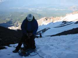
There were lots of folks on the mountain, and as we put on our crampons and got out our ice axes and roped up, the little strings of lights we could see above us were starting to resolve into little strings of ants with headlamps on them. And lots more people were starting at Lake Helen. Our guide estimated around a hundred people were there, which was amazing even to him. Anyways, we ground uphill towards the base of "the heart", where we were to turn right at and follow a narrow strip of snow up to the top. However, near the base of the heart, Ryan started dragging. We made our way up a bit further, and then parked well off to the side of a big rockfall area. He had not eaten much since our oatmeal, and he'd gotten chilled in a big way after our first stop down by Helen Lake, so that burned up most of his available energy reserves. He doesn't know why he hadn't eaten, but he definitely hit the wall, and was shivering and completely toast. He made the right call, and also got a guide back to the bottom.
After more food and water, we kept going up to the right of the heart. We kept passing groups. A surprising amount of people were heading back down. We kept going very slow and steadily. Ben kept a great pace. I felt like I could keep going for quite a while at it, even though I was tired. We climbed our way up to the red banks, where "the chute" was where everybody was going up. This is a narrow bit that is somewhat steepish that goes straight up the hill. There were lots of folks there, but we managed to cook on up and not get tangled up with anybody else. At this point, we climbed up to where the sun could see us, and it became a bit warmer. I managed to get us to stop for a bit to put on sunglasses. Later on, I put sunblock on again, but I figured that my 1am application would probably hold for a while.
We went on up to a little flattish spot right below "misery hill", which is a sort of featureless hill that is often massively windswept. For us, it was calm and nice. We took off our crampons and rested and ate and drank again. I was tired, but felt good, especially when we stopped. It was wierd. I didn't pant or feel tired or anything at all while stopped, but once I got going, it was pretty tiring. It was definitely altitude. But I used the rest step, and began using the "pressure breathing" technique that Ben and "the Freedom Of The Hills" mountaineering book gave us. And it actually helped out quite a bit! Afterwards, our guide remarked that I sounded like a steam engine. :-) I felt silly, but hey, it seemed to help, and so I puffed away.
We then began the journey up misery hill. I was feeling tired, but OK, so my pace was much slower than Shane, so he and Ben cooked on ahead. I made it up there in my own time, and we were blasted with some wind up there at the top. Crossing a small pool of icewater, we ambled across a snowfield towards the summit mass. I was getting rather tired at that point, and I felt pretty clumsy. But we made it across that and clambered over a rockpile to the trail. We wobbled our way to the top, and THERE WE WERE! At the top! Amazing! The view was incredible. Not to say that the view wasn't incredible from any of the other places we stopped too. I would have been happy to stop at any time and go back down if I had to. But wow. It was really cool. There was a ranger and a couple of other people there. On another ridge nearby, some maniac had camped. Another maniac came up a few minutes later behind us; she had worn a skirt! In all other ways, she was well outfitted, and she seemed very sturdy, but her legs looked blue... I wanted to take a picture to show Stephany how this woman had kicked some ass while still wearing a skirt, but I felt like it might be rude, so I did not.
So it was around 10:15-10:30am or so. And amazingly enough, we managed to beat all the other guided teams to the top, even though they had all started first. My theory was that they did this so that we'd have the most options of people going down. But we managed to get up there, and it was pretty cool. Truly, it was nice. Not life-changing or spiritual, as some people have said, but it was really cool. It was nice to know that we'd climbed a fairly high mountain. 14162 feet.
We took some pictures and headed down. I had to go very carefully, because I was still kinda clumsy, and my knee started to hurt a bit. We went down a different way, that not many people seemed to do. It was wierd. On the way down, we sorta outdistanced pretty much everybody. I don't know if everybody just hung out up there longer, or got stuck or decided to come down a longer way, or if we were just faster, but we walked along the top of the red banks, and then climbed down a notch on on the backside near the end and traversed along until we could climb down into some snow. From there, we glissaded down to Helen Lake, where we stopped for a while and looked at a big mudslide that had happened during the night there. Apparently, there was a loud noise, and a geyser of water and mud came out of the mountain above the camp, and a big stream of mud and rocks and so on flowed down to within a hundred feet of the camp there. Pretty darn cool. That mountain is definitely still alive. :-)
My clumsiness had mostly faded, but I was still fairly tired, and my knee hurt a bit more, so Ben and Shane pulled quite far ahead, as I was taking it easy. They stopped a few times to make sure I was in sight in case I fell or something, though. So we made it back to camp! Exhausted, but happy, we wandered in and met up with the rest of the group. I felt sad that they hadn't been able to make it, especially Ryan, who had been so focused on the goal. But they were happy that we at least had done it. So all was well.
We packed up and went back down to the car and drove home. The plastic mountaineering boots that we rented were amazingly comfortable, but in the heat of the lower elevation, our feet started getting hot and feeling blistery. But we made it down without any actual blisters! I had a nice time walking and talking with our guide, who hung back with me because I was still a bit slower than everybody else. And when we finally got to the car, we gave back the group gear and said our goodbyes to Ben, and we drove off. I tried to snooze a bit, but wasn't super successful. So by the time we got home, we hadn't slept for close to 22 hours. It was a long day. And my first day at my new job was the next day! For me, it was quite a week of change and challenge. And I _really_ enjoyed hanging out with Ryan and Eric and Shane and Ben. They were all great folks to go do stuff with. Ryan especially. I'm glad they asked me along. :-)
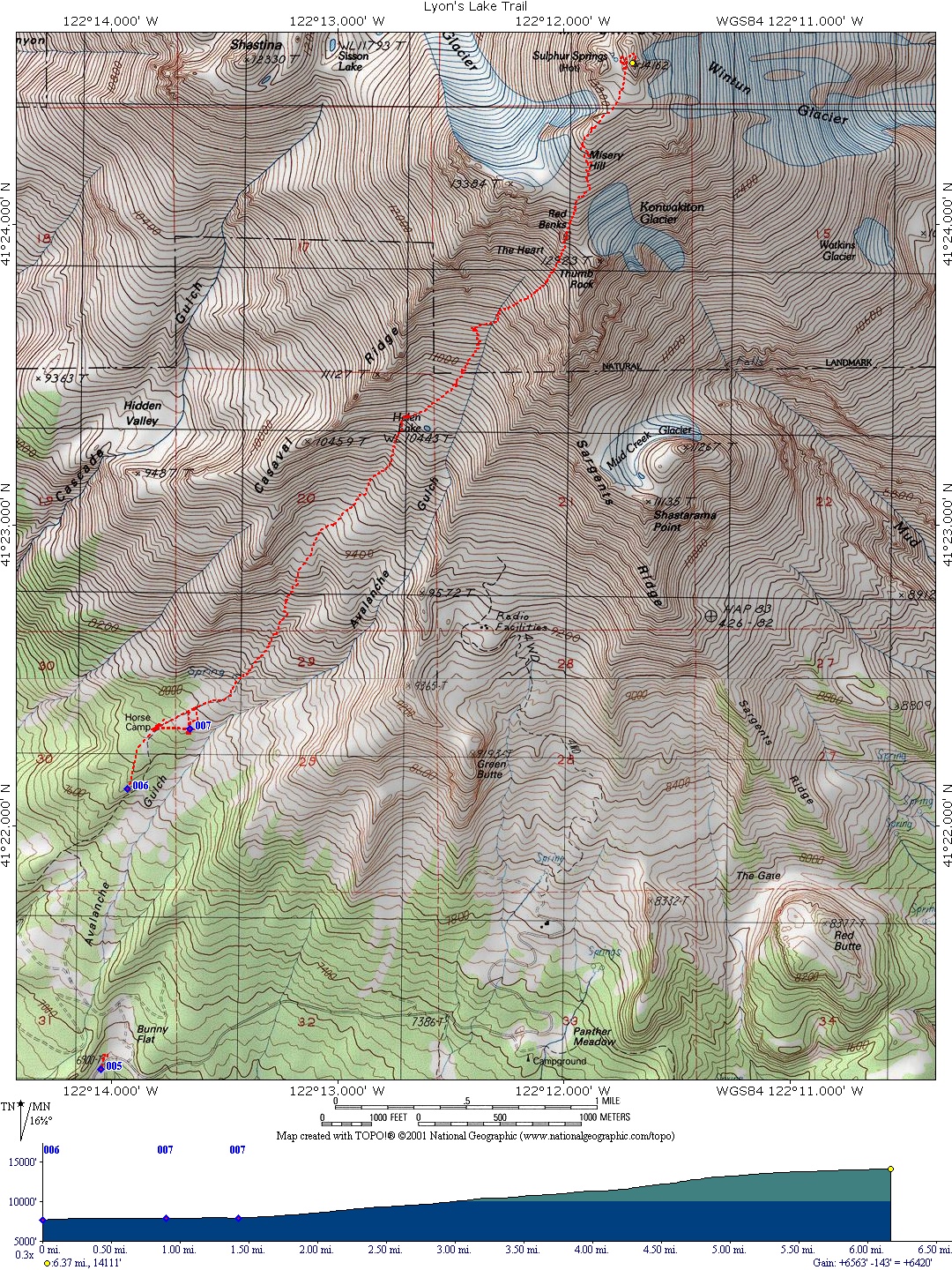
So here's the map of the route which we took. Unfortunately, my GPS unit turned off at the summit, so I don't have the descent route. I have no idea why it did this, but it was a little sad. Ah well. I must have squeezed it when I tightened up my pack or something.
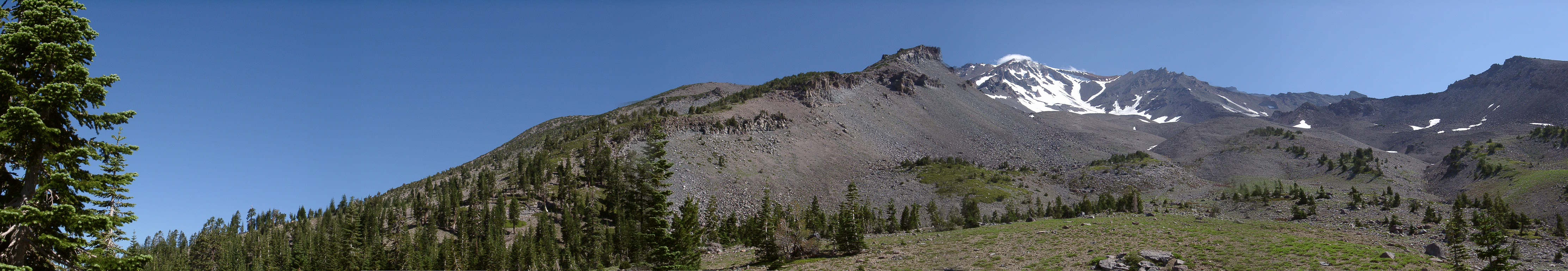
My pictures are here. Unfortunately, I didn't get as many as I wanted to because it was so hard to pull the camera out every time I saw something cool. And it was hard to capture the sheer scale of the place too, so in many cases, pictures wouldn't have really done the scene justice. And here is an amazing panorama that Eric took with his camera. Damn, it's cool! Also, Ryan took everybody's pictures and put them all together on his site.
Have fun!