Gluttons for punishment, we went back to the Emigrant Wilderness again, this time with Nikki, Steph's friend, in tow. She's one of those athletic types, so we let her carry the stove and water filter to slow her down. :-) This trip, we decided to go in to Granite Lake, which is sort of off-trail, though not by huge amounts. Maybe a mile and a half if you come at it from Bear lake, a half a mile if you come at it from Y Meadow Lake.
We did the usual stay at herring creek campsite, then drove to the ranger station for a free permit, then headed in. There was a fire burning in the wilderness. That was kinda cool. There were all sorts of signs saying that it was being let burn to try to let the forest re-balance itself after years of fire suppression. There's too much dead wood around these days, and so they try to left fires burn if they can, to reduce the danger of future fires, and to help the ecosystem, which is apparently rather dependent on fires in a lot of ways. So there was smoke off in the distance as we got to the trailhead.
Wow, there were a lot of people there! The Crabtree parking lot was full, and we parked on the road nearby. It was a nice trailhead, though. We could have camped there, probably, and gotten an earlier start. Maybe we'll do that. It seemed to be very busy this weekend. Herring Creek was almost full, after weeks of us going there and not seeing hardly anybody.
So we took off and headed towards Bear Lake. There were a lot of people coming out of the wilderness, actually, and not too many going in. We theorized that this was the "peak" backpacking time for the sierras, because of the nice weather (pleasantly warm during the day, and not too cold at night, not much rain or anything usually, etc.), no mosquitos (or at least a lot less than in July!), and so on. The trail was really easy. Nice light ups and down, but mostly just cruising along. There were some cool trees and some nice views off towards the fire, etc. Everything was nice and green from all the rain that had come last weekend.
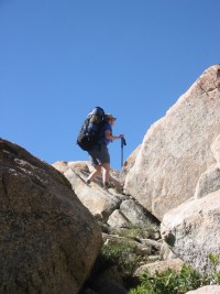
Then, we got to the turnoff for Bear lake, and followed it there. A large amount of folks were there, fishing and camping and throwing a ball into the water for their dog. It was still nice and quiet. We soaked our feet and enjoyed the sunny big lake. Then we moved on. We skirted the lake on the left side, following a sort of almost-trail to the end of the lake where we began to climb. There was no trail, and any other footprints from other people were definitely washed away. We climbed 1000 feet in about a mile. Quite a bit of it was some good two-handed scrambling, and I ended up putting my ski poles away to help me climb better. Steph had bought a walking stick, and she kept it out and it helped her out a lot. We would run into some cairns every once in a while, but it was pretty much a choose-your-own-path kind of thing. It was a _lot_ of work. Though near the end, we ran into these nice slanting glacial granite slabs that we called "the handicap ramps", which were SO nice because we were very tired.
We made it to the top, and there it was! We thought we would have the lake to ourselves after that amount of struggle, but no, there were 2-3 other parties already there! Luckily, the lake was shaped with many little coves and so on, so you could have your own little cove and not have to bother anybody else. It was nice. Lots of rock and little meadows filled with wildflowers! No wildlife besides a chipmunk or two, though we did see some mule deer on the road while driving back.
We set up camp and Steph took a swim (it was cold EVEN FOR HER!). We then hung out a bit and then got dinner going. As the sun went down, it got cooler, and we layered up. The night was absolutely clear and cool, and the moon as huge and amazing. Mars was bright as could be. We sat and talked about lots of fun stuff like backcountry skiing and mountaineering and other things which Nikki had done quite a bit of. I got inspired for next ski season. :-)
We went to bed, and bivied out in the open. It was quite nice! I thought I might be a bit cold, because I had the 30 degree down bag that has been to burningman twice and thus is somewhat dusty and not very lofty... But I kept my fleece and socks on, and was plenty warm all night. Steph woke me up sometime before dawn and we looked at the stars that came out after the moon had gone down. It was soooo amazing!
The next day, we were presented with a choice: we could go back down the way we came up, or we could walk out through Y Meadow Lake and then turn left at chewing gum lake and head back over a lesser trail to the trailhead, at the expense of a longer hike back and more elevation gain/loss. We decided to be adventuresome and take the loop hike back. Fun, eh?
We found our way over the hill and over to Y Meadow Lake. More off-trail navigation, and it was a little slow, but not much up/down, so it wasn't hard. We hit the trail at the end of the lake and cruised on up the hill where we ate lunch and discussed books and stuff. Still feeling good, we cruised on and took the left-hand turn into the Chewing Gum Lakes area, and rolled on into a BEAUTIFUL set of meadows with little small ponds and streams flowing through them. Wow, it was so pretty! We kept going to the end, and ran into a group that was camping in some trees which had a big dog which barked at us. We skirted around the barking dog group and made our way down a set of increasingly sketchy trails. There was a sort of washed out trail and a bunch of cairns that sort of petered out on top of a cliffy area above Bear Lake. We were definitely not where we were supposed to be.
We definitely were in the wrong place. I had forgotten to upload the basemap into my GPS unit, so it was only helpful in positioning us relative to our old trail, and for altitude readings (though later on, I realized I could have read the UTM coordinates on it and found where we were on our map). So I shot a bearing to the nearest peak that we could see across Bear lake, oriented the map, and correlated that with our altitude, and figured out that we were well off course, and that we needed to go around 4-500 feet straight up the hill to our right. Despite some lingering confusion about where we should go, and some last minute doubts that I had oriented the map correctly (It's been some years since I did any real orienteering), we set off and climbed up a very extreme slope, angling back and to the right. It was pretty exciting. It would have been a fairly stiff scramble even without packs, and with them, it was quite a climb. It didn't feel too dangerous, but we all looked down and realized that if we had fallen, we might really have rolled or slid for a looooong way.
And lo and behold, as we approached the ridge, the trail appeared beneath our feet! So be careful with the trails there. They aren't super well marked in all the places. We stopped and rested there at the ridge crest and had some celebratory water and luna bars. :-)
The rest of the way down was fairly even terrain. The recent rains had in places created deceptive "trails" that were actually streams, but it wasn't too hard to spot them, and aside from one bit where we had to wander around for a while, the trail wasn't too hard to find. Though it wasn't the best trail either. It had lots of rolly rocks and felt very long. :-) Maybe that was because we'd gone quite a bit of distance already that day... The sun was going down, creating some really pretty light, especially with the forest fires going on not so far away. It was quite nice.
Literally _just_ as Stephany and I drank the last of our water, Nikki saw an RV ahead through the trees, and we were back! I wouldn't quite call it an epic, but it was quite an exciting time. It was less of a backpacking trip and more of a scrambling trip. :-) We drove back home and stopped on our way to eat at an extreme prime rib place in lieu of the traditional burgers and beer. I hope that Bernd will forgive us. :-)
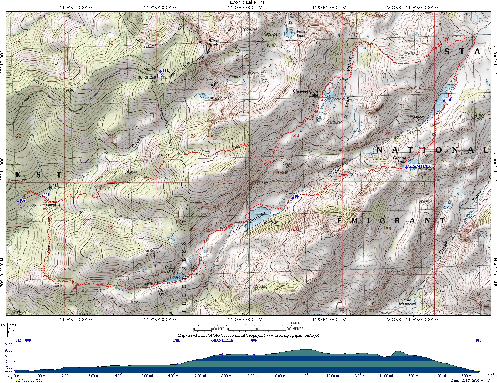
So here's the map of the route which we took. Note the bit above bear lake where we went off the trail and we had to fall back on map/compass to verify where we were. :-)
And guess what! One of the other folks who made it there that weekend actually emailed me! His site is here: http://home.comcast.net/%7Eteamsk/ew/Emigrant_Wilderness.html. Looks like they had a great time as well!
Have fun!